Description
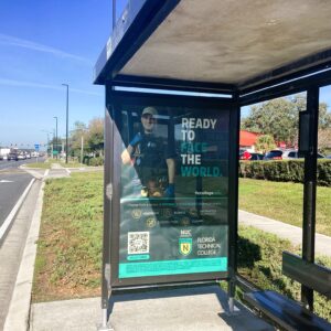
Illuminated bus shelter with 2 ad faces at Hwy 192 (13th Street) and Orange Avenue.
The bus shelter (illuminated at night) is located along E Irlo Bronson Memorial Hwy (US 192/13th St) at the intersection of Orange Avenue in St. Cloud, Florida (ZIP code 34769). This is a key commercial corridor in central St. Cloud, Osceola County, featuring retail, dining, hardware stores, and residential access. US 192 serves as a principal east-west arterial connecting Kissimmee to the west and Florida’s Turnpike/eastern Osceola to the east, handling commuter traffic to Orlando, local shoppers, and through-travel to Melbourne. The shelter’s placement offers strong visibility to vehicles on this busy highway, enhanced by nighttime lighting for extended exposure during evening hours, near Dunkin’ , D’s Ace Hardware, and Chipotle Mexican Grill. The area includes Mount Peace Cemetery and Hopkins Park, with moderate pedestrian activity from nearby businesses and neighborhoods.
Nearby Businesses, Landmarks, and Points of Interest (Within ~1-Mile Radius)
The surroundings are a mix of retail, quick-service dining, auto services, and suburban residential with green spaces. Key spots include:
- Retail/Services: Dollar Tree, D’s Ace Hardware, Mister Car Wash, Classic Collision.
- Dining: Dunkin’, Chipotle Mexican Grill.
- Other: Mount Peace Cemetery, Grove Ave residential areas, River Pkwy access, Crawford Ave neighborhoods, and small ponds/green buffers. This commercial strip supports daily errands, auto-related services, and family dining, with good connectivity via US 192.
Traffic Counts
US 192 in central St. Cloud maintains high volumes as a principal arterial, with AADT influenced by commercial activity and commuting. Osceola County 2024-2025 capacity reports and FDOT data indicate robust flows in segments near Orange Avenue, with steady growth from regional development.
| Road Segment | From/To | Year | AADT (Approx.) |
| US 192 | Michigan Ave/Oak St area | 2024 | ~57,000–57,800 |
| US 192 | Broader central St. Cloud | 2025 | ~51,000–57,000 |
| US 192 | Eastern/western St. Cloud segments | Recent | ~50,000–60,000+ |
Additional Notes on Traffic: Mix of local retail/errand trips, commuters, and through-traffic; LOS D indicates acceptable but approaching capacity in peaks. For illuminated bus shelter advertising, exposure is excellent—~50,000–58,000 daily vehicles (higher in evenings due to lighting), plus pedestrians/shoppers.
Demographics and Area Profile
ZIP code 34769 (central St. Cloud) is a diverse, growing suburban zone with family-oriented residents, moderate incomes, and strong Orlando commuting ties. Population ~29,000–31,000 (recent estimates; broader St. Cloud city ~71,000–76,000 projected for 2026+).
- Population Density: ~2,800–3,700 people per square mile.
- Median Age: ~36–40 years (young families dominant).
- Racial/Ethnic Makeup: ~56–62% White, ~39–48% Hispanic/Latino (strong Puerto Rican influences), ~6–7% Black/African American, ~1–5% Asian/other.
- Median Household Income: ~$58,000–$83,000 (rising with growth).
- Housing: Median home value ~$271,000–$313,000; mix of single-family homes, rentals, and nearby mobile communities; average household size ~2.6–3. This multicultural, moderate-income audience suits illuminated shelter ads for retail (e.g., Dollar Tree, Ace Hardware), dining (Dunkin’, Chipotle), auto services, or local promotions—targeting families, commuters, and evening drivers.
Visual Context of Nearby Roads
US 192 here is a multi-lane divided arterial (4-6 lanes) with medians, commercial frontage, grassy shoulders, and sidewalks. Orange Avenue is a local collector with residential access. The shelter benefits from highway visibility, nearby signals, and nighttime lighting.